
Himalayan Hazards Hub
A central repository aggregating cross-border hazard data to enhance regional safety. We synthesize information from diverse sources into a single, accessible dashboard for the entire Himalayan belt.
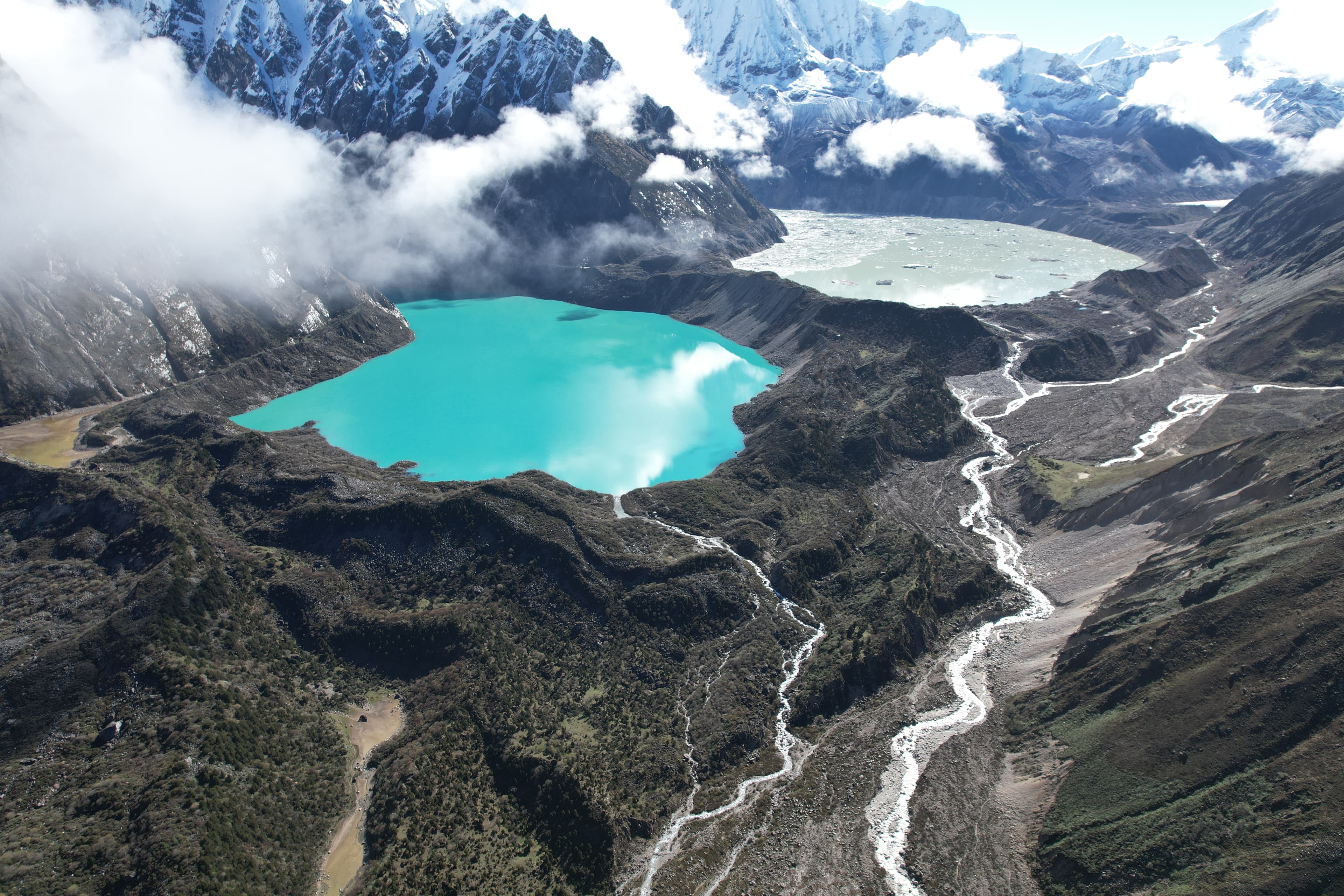
View Live DashboardThe Himalayan environment is evolving rapidly, in response to climate change, and the region is a hotspot of glacier loss, particularly in eastern areas such as Bhutan. As climate warms and glaciers shrink, the threat from natural hazards, such as floods and mass movements, is becoming increasingly pressing in the Himalaya.
Himalayan glaciers are critical water reservoirs, supplying over 1.4 billion people with water (~20% of the global population) and helping to sustain supplies during the dry season. This water is essential for hydropower generation, which is a critical source of renewable energy and is the primary energy source in countries such as Bhutan, and for agriculture, which is often the primary employer and a key contributor to local and regional economies. Thus, the Himalaya faces the dual challenge of evolving natural hazards and landscape change under a warming climate and increasing exposure and vulnerability, as downstream populations and infrastructure expand.
Our work aims to enhance scientific understanding of changes in the physical environment and natural hazards, and to determine the risk these changes pose to downstream populations and deliver tangible benefits.
Get Glaciers Data
Access a range of datasets and data tools to further your glaciers research.
Glaciers Data And Tools
Research Highlights
View AllAdvancing glacial lake hazard and risk assessment in Bhutan through hydrodynamic flood mapping and exposure analysis.
Hazard and risk from glacial lake outburst floods (GLOFs) in Bhutan have traditionally been assessed with limited consideration of the downstream exposure and vulnerability associated with individual lakes. However, exposure and vulnerability are key components of risk, and when explicitly attributed to each lake, can provide a more robust basis for prioritising hazard investigations and mitigation efforts. We modelled hypothetical GLOF scenarios for all glacial lakes with an area greater than 0.05 km2 and located within 1 km of a glacier terminus. We then determined GLOF risk by explicitly accounting for downstream impacts using depth–velocity outputs at each exposed element affected by the simulated GLOF from each lake, as well as the vulnerability of the affected community. Our study shows that approximately > 11 000 people, > 2500 buildings, > 250 km of road, > 400 bridges and ∼ 20 km2 of farmland are exposed to potential GLOF in Bhutan. We classified lake130 (Thorthormi Tsho) as a very high hazard glacial lake in Bhutan, five lakes as high hazard and 22 other lakes as moderate hazard. Among these high hazard glacial lakes, three of them: lake93 (Phudung Tsho), lake251, and lake278 (Wonney Tsho) were not recognised as being high hazard in previous studies. Five downstream local government administrative units (LGUs) were associated with very high GLOF risk, while eight others are associated with high GLOF risk. Five of these very high and high risk LGUs had not been previously documented as being at risk from GLOF. Our study underscores the significance of integrating potential inundation mapping and downstream exposure data to define high hazard glacial lakes. We recommend strengthening and expanding the existing GLOF preparedness and risk mitigation efforts in Bhutan, particularly in the LGUs, as having high GLOF risk identified in this study, to reduce potential future damage and loss.
Quantifying heterogeneous glacier dynamics in Lunana, Bhutan, using high-spatiotemporal resolution satellite imagery.
The Lunana region in Bhutan, which hosts four large glacial lakes with significant hazard potential, has undergone rapid changes over the past decade. Using PlanetScope satellite scenes, we mapped ice velocities at monthly intervals from 2017 to 2023. We reveal that the disintegration of Thorthormi Glacier’s terminus in 2022 coincided with year-on-year acceleration with mean surface velocities as high as 448 ±10.0 m a-1 by 2021, and seasonal variability in surface velocity magnitude >144.6 ±10.0 m a-1. This acceleration is attributed to a reduction in basal drag as the terminus reached flotation, evidenced by the calving of tabular icebergs. While Bechung, Raphstreng, and Lugge exhibited a similar interannual velocity trend, the upper regions of Bechung and Raphstreng showed a higher seasonal range (31% and 19.9% from their mean) compared to Lugge (4.2%). In the upper regions we also find a decelerating velocity trend (3.5 – 20.6% over the 6 years), which is attributed to surface thinning and reducing driving stresses. We show that accelerating trends in velocity can be a precursor to higher rates of retreat and rapid lake expansion, demonstrating the importance of continuous monitoring of lake-terminating glacier ice velocities in the Himalaya.
A Monitoring Network for Mitigating Himalayan Glacial Lake Outburst Floods
Glacial lake monitoring is urgently needed across the Himalaya due to the threatof glacial lake outburst floods (GLOFs). Furthermore, both the population and the infrastructureexposed to or dependent on these glacial lakes are increasing. However, there are a substantial number of glacial lakes in the Himalaya with potential transboundary GLOF impacts, and their remote, high-altitude locations make monitoring extremely challenging, so existing field measurements are limited. Here, we propose a benchmark Himalayan glacial lake monitoring network“HiGLMN” that will characterize glacial lakes by combining geomorphological signatures ofGLOFs, monitoring triggers and mechanisms of dam failure, and downstream impacts using insitu observations, remote sensing, and hydrodynamic modeling, and feed into early warning for disaster mitigation. We also provide existing practices to support the effectiveness and necessity, and propose strategies for future data management. The monitoring network will contribute to robust GLOF risk management, early warning, and mitigation.
Exploring implications of input parameter uncertainties on (GLOF) modelling results using the state-of-the-art modelling code, r.avaflow
Modelling complex mass flow processes, such as glacial lake outburst floods (GLOFs), for hazard and risk assessments requires extensive data and computational resources. Researchers often rely on low-resolution, open-access datasets and parameters derived from plausibility due to the difficulty involved in conducting direct measurements. This results in considerable uncertainties in forward modelling, potentially limiting the accuracy and reliability of predictions. To determine the sensitivity of the model outputs stemming from input parameter uncertainties in the forward modelling, we selected 9 parameters relevant to GLOF modelling and performed a total of 84 simulations, each representing a unique GLOF scenario in the physically based r.avaflow model. Our results indicate that mass-movement-triggered moraine-dammed GLOF modelling outputs are notably sensitive to five parameters, which are, in order of importance: (1) volume of mass movement entering the lake, (2) DEM datasets, (3) origin of mass movement, (4) entrainment coefficient, and (5) basal friction angle. The GLOF output parameter resulting from the volume of mass movement entering the lake has the greatest coefficient of variation (CV) (47 %), while the internal friction angle had the lowest CV (0.4 %). For future GLOF modelling, we recommend carefully considering the output uncertainty stemming from the sensitive input parameters identified here, some of which cannot be constrained before a GLOF and which must be addressed using statistical approaches.
Join Our Community of Himalayan Data Users
While our data is openly available without restriction, creating an account allows you to access advanced visualization tools, download datasets, and receive real-time alerts for critical threshold breaches.
Learn About the Benefits